Opportunity for Public Input on Newtown Creek Draft Damage Assessment Plan
March 1, 2024
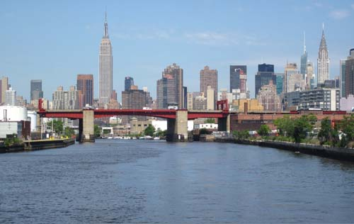
Newtown Creek, a waterway that forms a border between the boroughs of Brooklyn and Queens in New York City, flows into the East River and is part of the New York-New Jersey Harbor Estuary. The waterway has been contaminated for decades by releases of polychlorinated biphenyls (PCBs), heavy metals, volatile organic compounds (VOCs), pesticides, polycyclic aromatic hydrocarbons (PAHs), oil, and other hazardous substances from the many industrial operations along the creek. These releases have resulted in degraded water quality and contaminated sediments. Petroleum products have seeped into the creek for decades from an underground source estimated to contain millions of gallons of oil and related products.
The Environmental Protection Agency (EPA) listed Newtown Creek as a Superfund site in 2010 and is conducting an investigation to identify the full extent of the contamination and the potential risks to human health and the environment. Subsequent to oil observed entering Newtown Creek from a Brooklyn shoreline in 1978, the New York State Department of Environmental Conservation (NYSDEC) has overseen the recovery of over 13 million gallons of petroleum products from the site.
In 2012, NOAA, the U.S. Fish and Wildlife Service, and New York State Department of Environmental Conservation, as natural resource Trustees for Newtown Creek (Trustees), completed a preliminary assessment screen, the first step in the Natural Resource Damage Assessment and Restoration (NRDAR) process.
NRDAR is the regulatory process to determine the amount and type of restoration needed to compensate the public for injuries to natural resources resulting from the release of hazardous substances and oil into the environment. The Trustees are releasing a Draft Natural Resource Damage Assessment Plan for public input and comment. The Draft Plan describes the Trustees’ proposed approach to assess natural resource and resource service injuries resulting from the release of hazardous substances in Newtown Creek. The Draft Plan also focuses on environmental resources in Newtown Creek including sediment, surface water, and biological resources such as invertebrates, aquatic vegetation, fish, birds, and aquatic-dependent mammals as well as the ecological (e.g., food web) and human services (e.g., recreational opportunities, community connections) provided by these resources.
Get Involved
The Trustees are excited to share the Draft Natural Resource Damage Assessment Plan (PDF, 53 pages) which outlines injuries to natural resources related to the releases of contamination. Public participation is an important part of the NRDAR process. We encourage members of the public to review and provide comments on the Draft Plan.
The Draft Plan is available for comments until May 30th, 2024. After the comment period closes, the Trustees will review, summarize, and incorporate comments as applicable into the Final Damage Assessment Plan. If you have any questions about the Draft Plan or the NRDAR process, please send them to nrd@dec.ny.gov. A hard copy of the draft plan is also available at the following locations:
Queens Public Library
Sunnyside Branch
43-06 Greenpoint Avenue
Long Island City, NY 11104
Tel: (718) 784-3033
NYSDEC
Region 2
4740 21st Street
Long Island City, NY 11101
Attn: Natural Resources Supervisor
Your comments on the draft plan must be submitted in writing, either electronically to nrd@dec.ny.gov, or by mail to:
New York State Department of Environmental Conservation
Natural Resource Damages (NRD) Section
c/o Alicia Pasos
625 Broadway, 14th Floor
Albany, NY 12233
For more information and to stay in the know, sign up for DARRP’s Coastal Recovery news.


